One of the advantages of always trying to generate content – for here and social media is I have become fairly snap happy, both with the phone on my camera and the little MUVI camera I take out from time to time (think poor mans GoPRo).
So here it is then, a moments reflection on the previous year and some highlights, for each month in pictures…. (click on them to expand)
January 2018
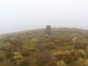
Taken on the 20th January this was an organised reconnoiter of The Stan Bradshaw Pendle Round. designed to get potential participants familiar with the route. Its a great race and one that novice to intermediate fell runners can get a lot out of and the top end experienced fellrunner can really race in – its “runnable”., unless the weather is atrocious – which it was for 2018. The race is in March – we had to manage the Beast from the East… this recce was in much more benign conditions.
February 2018
Outdoor Elements in the snow. As a freelancer I work for all different types of organisation. OE are definite favorites! its a charming site to work at all year round.
March 2018
Whilst Safety Marshaling for Outdoor Angels/High Terrain Events. Their Buttermere Trail run took place on a stunning day. Luckily I had taken my running stuff up so I could get out for a trot once stood down.
April 2018
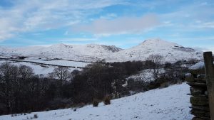
This view from the top of Pendle always gives people cause to stop and take it in. Even the most reluctant of walkers (from the local Activity Centre – Whitehough) seem to appreciate the views across to North and West Yorkshire as well as Bowland to the North East.
May 2018
EYFS outdoors is very important to me. The opportunities I create, most 3&4 year olds simply do not get these days. Such as wandering along a river exploring and discovering a whole heap of new experiences. Taken at Outdoor Elements hosting a regular Nursery School of mine.
June 2018
I love this photo. Proper concentration! A session for families, for WAVE Adventure, supported by BBC Children in Need. A walk around Rivington in order to learn some basic map skills. here they are orientating the map and matching the paths to their current location.
July 2018
Yorkshire Three Peaks. One of my favorite days out. This day was guiding for another provider. Great group, great weather, beautiful views all day. This pic, taken at about 7.45am I think really sums it up.
August 2018
Rock Climbing. Another WAVE Adventure/BBC Children in Need session for families. These three are awaiting an abseil and were posing for the shot admirably…. I however wanted the silhouette rather than their characters. that said, the character of this picture is ace! I was lucky to meet and support some aspiring outdoors professionals running these WAVE sessions.
September 2018
Ghyll Scramble at Barbon Ghyll in the Yorkshire Dales with Sedbergh Preparatory School. Great kids on their way to a great afternoons adventure.
October 2018
There have been some tough decisions in terms of highlights this year, but this month, October I really could have had five or six and in the end narrowed it down to these two. Thistle Cave with Sedbergh School (again), I loved this session, one of my favourite for the year and has given me a new direction to pursue in 2019. The Pendle Hill pic taken as part of a personal group run. Every Tuesday throughout the winter I run with my club mates around the Pendle area. This was one of the first of the winter runs where you start in the light and finish in the dark. This one at sunset is probably my favourite picture of the year and has been shared amongst that group extensively!
November 2018
A WAVE Adventure young Mentor doing her thing without assistance getting ready to climb. Taken at Bolton One, possibly the smallest climbing wall ever, but very group friendly and very accessible.
December 2018
I have wanted to make campfire pizza for ages. Normally one tests the idea, does it a few times to get the session slick and imprinted in ones mind. This one, nah off the cuff and made up as we went along! At Outdoor Elements with a regular school booking (PRU). Wow. Its amazing. The kids (13-15) loved it, we made the dough, sauce and toppings all selected by the group and made 3 pizzas. A session to be repeated!
I am far from original when I post on social media another “todays office” picture. I am lucky to work in the parts of this country I work in across the north west. But…. and you saw that coming I am sure, It does tend to be the same parts! So mid way through the silly season (April to July) I hatched a plan to get some hill time for myself as a solo mission…. between work, holiday, parenting, my wife’s work and life and stuff we narrowed it down to a window over two days in early August. So that was that then.
My plan was to bag a few Wainwrights in an area of the Lake District I did not really know. What with the weather we have been enjoying this summer, one could almost say I was getting quite excited! some hill time, a wild camp, more hill time and a pass to enjoy them. Brilliant!
I decided on the Northern Fells, beyond Skiddaw Forest/Blencathra. I had not been up beyond there before and decided that nine of these hills/mountains could be strung together in an approximate 30 km route. Over two days this would be ideal. Whats more having finally got my entry in for the ROC Mountain Marathon, I could use this as training and so treated it as a “fast & light” exercise the aim being to achieve a gentle run, practice some micro nav and do all that carrying a mountain marathon kit list on my back.
The afternoon of August 3rd arrived and once I’d tagged my wife on the parenting front I set off, slightly later than planned up the A65 to avoid any M6 Friday northbound problems. I found road works instead! Eventually arriving on the road out of Mosedale where I figured there would be somewhere to park – there was (thank you Google Earth), plenty of spots fortunately. I set off at 17.00 (I’d hoped for 3.30-4.00 ish) in gentle drizzle, warm, but you could see that the visibility would be limited on the tops.
The first objective was Carrock Fell (663m). I’d planned a fell runners line straight out of the valley, anticipating an element of bushwhacking – it being the height of summer and the ferns at their deepest. what I hadn’t anticipated was the density of the heather, the amount of gorse and the scree banks peppering the sides of the fell. Although steep, the angle in fell shoes is not intimidating (go Mudclaw 300’s!) but what was tricky was the combination of loose surface, prickly bushes and impenetrable shrubbery! I’d clocked a path on the map and decided to follow that up, the path ended on the map, usually they carry on in the real world on the ground… this one may as well have met a brick wall! I couldn’t get round the gorse and scree combination, so I retreated back to the road thinking I would just jog the 2.5km on tarmac to the actual right of way up Carrock Fell, unless I spotted a clearer way through the undergrowth, which I eventually did. Phew. By now the weather was lifting and I was fortunate to get a shot like this:
Two thirds of the way up Carrock Fell
Carrock Fell has a real charm to it. With old earthworks and stone formations on top (‘fort’ on the map), it is also right at the edge of the park and offers great views over the less hilly parts of Cumbria to the east.
Pleased to have finally bagged the first hill of the day an embarrassing two hours hours after I set out, I hatched a plan that the next hill – High Pike (658m)- would likely be the last today, aiming too have topped out on this an hour later or so at 8 pm. After the top of that hill, I would then find somewhere to pitch up for the night. That gave me plenty of time to find a good pitch, get water and feed myself in day light. I had a couple of locations in mind looking at the map, but had given myself plenty of time to choose. Site selection really is the difference between a good nights sleep and a poor one when wild camping. By now the visibility had dropped again and the mist was down, making progress slower but to be honest much more fun! I had to proper navigate! Great Mountain Marathon practice, using aiming off, hand rails, catching features and timing I got to a misty High Pike at 20.01. Perfect timing!
Although I enjoyed getting to this one in the conditions, I bet the views on a clear day would be amazing. One to re-visit.
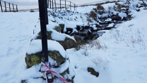
My first choice on the map wild camp spot was just off off the Cumbria Way by a gil which looked like it might offer both fast flowing water and several flatter areas. Off I set in to the gloom…. it was not long before I noticed this:
look carefully!
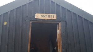
A building? I checked the map – yep definitely – a tiny one – marked on the map but not one I had noticed, choosing the breadth of Cumbria Way and a sheepfold and water course or two to navigate by. Well a building may provide shelter from the wind, it was on the track so I knew I was destined to check it out. As I got closer I saw the door was open and it dawned on me it was one of the Lakes Bothys. A bothy being a simple shelter designed to offer a roof and walls for the night for free,to whomever needed it. Some are literally just that, four walls and a roof, others are quite stunning with open fires or stoves, tables and chairs. Now this was a game changer! Never mind wild camping when there is a bothy on the menu!
I got closer to…
And a voice loomed out of the dark – “alright mate” Rather making me jump, but in I bowled to say hello to the occupant. First thing I noticed was he was the dead spitting image of an old mate of mine (Duncan) he even sounded like him weirdly. We got chatting – he didn’t seem like an axe murderer (I couldn’t see an axe) and said he would be grateful for the company as he was on a through hike – self supported – of all the Wainwrights (that’s 214 hills!) as his holiday. That was my decision made – anyone doing that in one go would be well worth the conversation, so I decided to sack off the tent and go for water to then return and spend the night in the bothy. And what a top decision that was to be!
Kyle, as it happened lived in a town 20 minutes from me in Burnley and worked in the outdoors. This meant he must work for Robinwood – yes he replied! Which meant we would know some of the same people, which of course we did…. small world indeed. Kyle was a great chap to natter to for the evening and when the time came to close the door and batten down for the night, the bothy decision was looking inspired… until 8 minutes past 2 in the morning when some voices could be heard outside:
” Oh look a bothy”, “yeah, thats Lingy Hut” “shall we look inside?”, “no we better not, in case there is someone in there and we wake them”
Too bloody late for that mate!
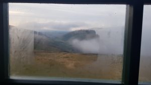
A bleary morning followed but the forecast better weather looked like it was on the way for the day.
the view from the window of Lingy Hut
Kyle was up and away early I took a more leisurely pace getting ready. To be fair poor sleep on top of a dodgy dehydrated meal I had ‘tried’ the night before and actually abandoned a few spoons in to it – it tasted and smelled chemically vile – had left me feeling a wee bit fragile….
A big part of the Bothy Code is to leave the bothy better than you found it. So I made sure I gave the place a good sweep through and took some other peoples sweetie papers with me and by 7.30 am I was off to collect seven more Wainwrights and several connecting hills between them. The weather was drier for sure but the cloud base was low – about 550 to 600m so I was back on nav mode and moving well, fueled by Haribo, Babybel cheese, coffee and a cereal bar or two.
Next on the list was Knott (710m). The biggy of my plan and from here had it been clear I would have been able to see all the target hills for the day. Never mind!
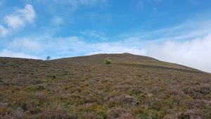
Tempting as it is to post a number of pictures of summit cairns surrounded by mist I shall resist… The day passed quickly and I felt as though I was making good steady progress and feeling stronger than I thought I might having not tackled this number of hills at pace in a while. From Knott, I headed to Great Sc Fell (651m) to Little Sca Fell then on to Brae Fell (586m) which looked lovely in and out of the mist, before climbing back up and over some gils toward Longlands Fell (483m) Lowthwaite Fell, Meal Fell (550m), Great Cock Up (526m) then ascending Burn Tod, over looking Frozen Fell targeting Little Calva and Great Calva (690m) to then descend back to the valley bottom and return to the van.
By Little Calva the weather was lifting and the sun was becoming el scorchio. The last 90 minutes of my foray were very pretty but tough in the heat. The whole area is one to visit again…. if only I could guarantee the views!
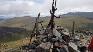
the top of Great Calvalooking back up to Great Calva following a never ending descent through acres of heather.a welcome stream to cool tired legs and feet.
I got back tot he van just before 14.00. Perfect really as the van was still there and I had said I would be home around 16.00.
Cant wait for the next trip out – it was great and has reignited my desire to bag the Wainwrights. 118 done, 96 to go….
To contact me to discuss navigation training/coaching for walking or running or indeed any other hill skills you can contact me here.
Another winter, another Open 5 series… Yay! I look forward to these in a big way, once Barley Badgers start night running on Pendle again I know its not long to wait before the Open 5’s kick off. Previous Open 5 posts and an explanation of the format are here. This season there are only three events, every other month which I am disappointed about, but with Dark Mountains coming up in January, perhaps that’s no bad thing!
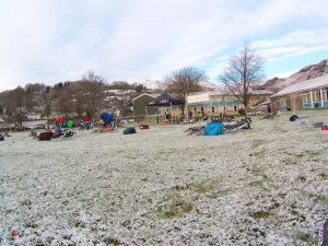
Coniston. An area I know well having biked, walked, run, camped, climbed and raced around before, bring it on. Feeling quite fit, with a sound bike under me I was fired up… the only curve ball might be the weather. the forecast for the preceding few days was for heavy snow, with yellow and amber warnings from the midlands up I loaded a van on Friday ready for an epic journey and was prepared to battle up the night before to ensure I could reach the start line….but on the Saturday (day before) the forecast changed and it looked like benign conditions, for the journey and settled snow and ice around Coniston with sunny skies promised too. Perfect conditions for an entertaining race.
With low level patches of snow and ice and definitely snow on the ground the scene was a pretty one.
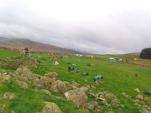
Start/Transition/Finish area at John Ruskin School, Coniston
Last season I had biked first, then run. Time to go back to run first then bike. The theory being no matter how tired I am I can bike faster than I can run and if all else fails I would be able to walk and push the bike. Last seasons experiment hadn’t done anything to convince me biking first was a better bet.
The first job on collecting the map for me is to try and come up with a possible run and bike strategy, its a rough sketch of a plan as the control points values are not given to you until you cross the start line and the clock is ticking. This map revealed a few controls along the lake shore, meaning a good flat run, that appeals to me as it gets me warmed up and the blood pumping rather than straight over the line and uphill – which any where north of the Start line would be, so subject to points values, I would be heading south first. The bike was more complex with some fast roads in and out of Coniston and a big hill or two in either direction I decided it was an anti or clockwise choice, involving the quarries or not subject to how many points were available.
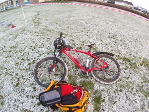
Ready to go.
I started at 9.21 by my watch, meaning I had to be back for 14.21, I knelt down on some dryish looking tarmac to mark up the map…clock ticking. My plan was sound for the run, the bike bit was looking like skipping the quarries and heading east first. I would reflect more on that later. So I tore off at a good pace heading toward Coniston Hall and the water. With three controls bagged in the first 25 minutes I was feeling good and the conditions although intermittently slippy (wearing my usual roclite 280’s) it was definitely runnable. Sub zero and crisp – a beautiful morning! I try to bag points against time and scoring something every fifteen minutes is my usual aim, I was well on plan… but maybe I paused and took one too many pictures..? Still part of doing this is all about appreciating where I am. Well it is for me anyway!
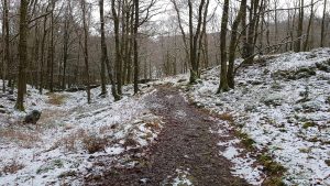
Torver Common Woods
The real uphill began at Little Arrow, a path I know well and my aim was Walna Scar Road to pick up the furthest westerly controls before heading back to Transition, bagging a few more on the way. Its been a while since I last ran in snow and it definitely hit my pace, but by now I was just beaming, I love running being out in conditions like this.
Looking north to the Old Man of Coniston
The Walna Scar Road was a mix of runnable compact snow and icy patches easily avoided. I knew it was time to start heading in once I had bagged 34 on Torver Bridge, but a part of me was thinking its cracking out here, should I just complete the run course and get all the points (250) and give myself only a short bike? But no, I bailed out of that thought process as there are 350 points available on the bike so I picked up the controls close to the main track on my way back in (32&30). I did take a tumble on the hill into town, some black ice caught me out, but in true fell running style I bounced back up, although as I type this my elbow is still bloody sore!
The furthest west control worth a meagre 10 points…looks pretty though.
At transition I prepared to bike and whilst slurping on some soup and scoffing a scotch egg (the food of champions) I nailed my bike plan down to east first toward Hawkshead and then north toward Skelwith. I knew most of these tracks and roads so figured with an unknown quantity of ice on the roads I would manage that better on familiar territory. The plan started with control 16, worth a bold 30 points…… which wasn’t where it was marked on the map. I expected the way mark with control on it no more than a couple of hundred metres from the buildings, yet I reached my catching feature (a sharp bend in the track with no control. I stopped and checked the map again, measuring for accuracy… I knew where I was for sure, but no control. I noticed a marshal on the course – very rare to see one of those on these events…”so where is it then?” I asked, “a bit further up” was the reply, so I carried on and sure enough another few hundred metres up the track there was a marshal holding control 16 in his hand, “its in the wrong place then eh?” I offered, “yes, we are thinking of moving it” came the reply. “I would” -beep-“cheers!”. In the seven years I have been doing these events I think is the first time a control has been marked on the map wrong/placed wrong (depending upon how you look at it). No big issue, It cost me maybe three or four minutes or so maximum. Onward!
The next few controls were where I expected them to be, so things were going well. Really well to be honest and I started thinking this could be a really good day following on from a great run, a fun bike trip and then a possible good score (350+ ish I reckoned) to boot! I got to control 11 with my plan being to head up and over to 10 before hitting Hodge Close and then the fast track back to town. I had an hour to play with and felt confident of squeezing it all in time. I then looked at the on the ground conditions – boggy icy hell it looked like, up a steepening hill, a theory supported by the chap coming down, who suggested it was like that all the way up, I would be managing a slow trudge at best, so I decided to drop control 10 (worth 20pts) and pile down to Yewfield and go over Tarn Hows to pick up the main road, control 14&15 and then in to the finish, if I got there sharp I could possibly get the 20 pointer at Hodge Close there and back. Head down and peddle!
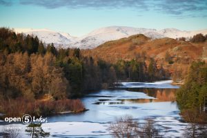
Tarn Hows looking lovely. Picture by James Kirby.
It was looking like a good plan right up to to the point I got to the parking place at Tarn Hows. The road down the hill on the other side was sheet ice and looked and felt treacherous. I stayed on my bike, but images of a fast descent froze in the winter sun and I trickled down the tarmac hill painfully slowly. I got to 14 knowing I was going to have to drop the 20 pointer at Hodge Close, but I had time (about 15 minutes) to get back in the five hours,so I set off at a pace to be proud of 4 hours 45 minutes into the event and was buzzing right up to the puncture! My first ever competitive puncture! ARRGGGHH! I reckoned I had just under 2km to go and a control to find. I think I got the hole dodging some kids on the track out for a walk, I am sure I went over a bramble branch and that’s what got me (as I write this I have yet to repair it…). My thought process was this, put a new inner tube in and peddle back, having got really cold (hands especially) and be late in or just run the bike back in, be late – but stay warm. Well, warm won out so I started trotting… Thank you to all those who inquired if I was okay..”yep, just a puncture” was the often repeated reply, I got 15 (worth 30 points) with three minutes to spare and I eventually crossed the finish line seven minutes over time. Bugger! The points loss, coupled with the forty points I Left on the course left me with a disappointing 314 after penalties, well down the field.
Whilst chatting to other competitors (Steve and Andy) it turned out I wasn’t the only one who had considered having a long run and shorter bike – they had executed that plan and done really well on it scoring 370 each! Next time I might give that plan some more serious thought, I would say I am a better runner than MTB’er. Having scanned the results there were some big scores which seemed run heavy/bike light. Perhaps I missed a trick there.
Irrespective of a disappointing result I had a fantastic day, the course planners did a great job offering some testing route choices and well positioned controls. Roll on Edale in February!
Confidence was high approaching this Mountain Marathon. Following the (still) amazing result at the OMM Lite a few weeks ago, described here, I was well up for the ROC, formerly the RAB. This event has changed quite a bit over recent years as the new owners (Ourea Events) seek to leave their mark. What attracts me to this event is that you can compete as a solo. Most MM’s are aimed at teams of two, so this one is a real novelty. This would be my 6th RAB/ROC.
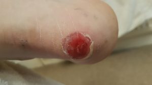
Since the OMM Lite, I had kept my running to a minimum, wanting to be rested for the ROC and had decided that my regular Tuesday CleM runs (about 10-13km per evening) and one other 10km run the weekend between would be enough to ‘turn my legs over’. the Tuesday before the weekend I went off for the usual session BUT with new Mudclaws on. Fresh out of the box, I wanted to bring these in to circulation as the RAB previously has finished shoes off – and I mean absolutely trashed them, so I thought I would be ahead of the curve and get some km’s on some new shoes, leaving my regular pair ready for the weekend. That was mistake number one! I have worn classic Innov-8 Mudclaw 300’s for the past x many years, I have had well over ten pairs, same brand, model and for the last three pairs same colour and probably even the same batch, as I bought a job lot from Pete Bland Sports in a sale. This was the last pair from that batch – why would they be any different? Clearly they were and for whatever reason, this pair gave me a hot spot on my left heel two km’s in to the run and by km three I knew I had a blister… I stopped, had a look and thought with a bit of re lacing I could get back to the van/pub at a slow trot. Wrong. Within 500m I had bent the back of the heel down and was running gingerly as I was now wearing the equivalent of fell running Crocs…. (a gap in the market may be?) I left the group and made my way back to the pub.
The blister,from the Tuesday evening run. Picture taken on the Thursday evening before the ROC weekend.
I am pretty good at managing and treating blisters, learnt over many years walking, running, first aiding on running events and reading many articles/books etc, particularly “Fixing Your Feet” by Jon Vonhof (well worth purchasing – here) so I was confident I could get to a point where I could trot round the ROC, I may not get the result I was hoping for, but still, I would be there… with expectations suitably lowered.
The ROC arrived, or rather I arrived in South West Cumbria, in the shadow of Black Combe, near Millom and I was ready to start and collect my map and control sheet. The premise behind a “score” event is you have a time (6 hours day one, 5 hours day two for the ROC) to find as many controls as you can over a given area. You get the details at the start line and it is part of the challenge to formulate a plan/route that allows you to collect as many controls on your electronic dibber as you can and get back to where you need to be – in this event an overnight camp- before the time runs out and you start to lose points by way of penalties. I have lost all my day one points before on these events… gutting to say the least!
Mistake number 2 then was a real school boy error. somehow in my haste I marked up the map incorrectly and gave a control a points value when it wasn’t in fact live that day – or indeed in use at any point over the weekend! This tipped my route choice into a direction I otherwise wouldn’t have taken. I realised my error as I was charging along to what I thought was the first control. I reached for the control description, expecting to see something like “stream source” or “spring” looking at how the map was marked but what I found was nothing. Control 210 wasn’t even on the live list, so why and how I had given it a value of 10 points was beyond me. I quickly checked the others I had marked…. all fine. Phew! Not for the mad house yet then… but that took up more precious time. Oh well, I will carry on, I will lose more time if I head back and take an alternative route from the start, the next control about a km away, was in my plan anyway, I’m just down a few points than I had expected.
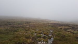
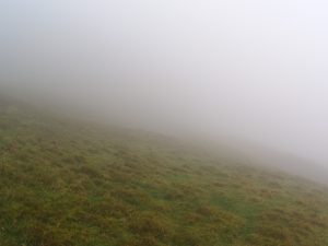
It was at this point that the cloud came in.
The weather forecast for Saturday was clear, overcast, but not raining and clear visibility on the tops. By 10.30 am the cloud base was down to about 400 m, it was very damp in the air and any chance at a view was lost.
Famous Lakeland scenic vista.
Now I am a good navigator and back myself in poor conditions like this, but with a scrambled brain from trying to understand why I had made a control up, sore heel and still cursing myself for starting so poorly my relocation took longer than it should have, with the added pressure being against the clock brings I was getting decidedly cranky! Several expletives may well have passed my lips, much to the amusement of the ever present Herdwick Sheep on Black Combe. Rumours I asked ‘lost’ fell runners still on the hill from the 2016 championships held here are unfounded.
I got there in the end- the next control a 20 point one loomed out of the mist. The game was on! I tore off north east following a trod heading gently down I was certain about my location and where to head next and the terrain was very runnable. This would still rank as my worst start ever – 2 hours in and only 20 points! I then came across three other competitors, a solo male and a male pair, all studying their maps and with compass in hand. They didn’t know where they were with any great conviction, so I advised them accordingly. “We’re here mate”, much gratitude was expressed and the pair carried on their way, the solo – a chap named Dan on his first MM asked to team up for a while. Sure, with no view, conversation would be good for the next few km’s!
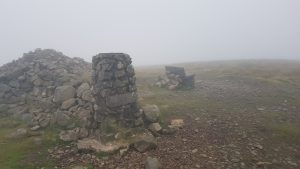
“OS Trig Pillar” control description
Dan was clearly a better runner than I and as we got lower down and the visibility improved he sped off to follow his own plan.
From here on in I was navigating to my usual standard and hitting controls exactly where I expected them to be. I still get a massive buzz from that, but essentially the damage was done. The poor tactics, dodgy heel and slower going in the clagg meant I was in damage limitation mode and the main objective was to get back to camp without incurring penalties, which I was able to do and got back in with a meagre 200 points and four minutes to spare. My plan had seen me get somewhere between 270 and 300 which would have left me comfortably mid table at half way, instead I was languishing in the bottom 20 or so 90 something out of 113.
But tomorrow was another day!
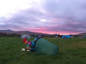
Overnight camp. Mine is the green tent on the left…
Day two and the weather was much improved.
Sunrise, early in the morning, making all the runners look around…
Feeling good and less achy than I usually feel on day two of these things and with a heel blister that hadn’t got any worse I was raring to go and at 8.13 am I dibbed out of camp to head back via as many controls as I could in a bid to make amends for the previous days woes.
And oh what a day. Stunning conditions, runnable, although wet ground and with clear visibility. It was like running a different event, my route choice saw me tackle some controls I had visited the previous day (all correctly marked up this time!) but the views were stunning, with Eskdale and the Scafell Massif to the north and the Irish Sea and coast to the south and west it was a view to inspire.
The going was good and I was pleased with my lines and nav to the controls. We were all wearing GPS trackers supplied by Open Tracking (part of the Open Adventure team) and being able to review the routes you took is an excellent feature of the ROC -one I hope they continue to maintain. You can see my day one and two routes with each click search for my name or “303”.
By two hours in from the five I had about 120 points… a much better haul! My day two total was 300, which placed me 53rd on the day from the 113 that started – which is where I usually am, mid pack, but because of day one’s error and conditions I finished overall in a disappointing 75th. The heel is now healing nicely and although somewhere between uncomfortable and painful did not get any worse which was pleasing. Just as well as I am DofEing this weekend for Sam Sykes Ltd down south so will be on my feet all weekend.
I almost wish I was competing at this year’s OMM… I’m gonna have to wait till 2018 for my next Mountain Marathon fix… Still, the adventure racing season is almost upon us!
This short video captures the 2017 ROC nicely I think.
For those interested Kit wise I used:
OMM 3/4 length leggings, TNF boxers, Injinji socks ( a pair for each day), and a Berghaus LS tech tee. I wore a Haglofs windproof gillet also as main kit with an Innov 8 cap on top.
I had a Montane Minimus smock and over trousers, both worn at camp. Also a Montane fleece jacket thing – very light and a Rab micro down jacket and New Balance full length running tights and a Montane beanie hat all worn at the over night camp and meeting mandatory kit requirements. Gloves (Aldi Merino ones) and a buff (race swag) were carried but not worn. I ran in Mudclaws – the classic 300s with the proper 10mm lugs – a well worn in pair!
I slept in a PHD bespoke down sleeping bag, with a silk liner on a 3/4 Thermarest Neo Air mattress which has a slow puncture despite multiple repairs, it takes all night to go down, so it kinda works. Tent wise it is a TerraNova Laser Photon 1, with a foil blanket as a foot print to protect the floor. I use Alpkit titanium pegs rather than the tooth picks the tent comes with. I cooked on an Optimus Crux Lite stove and used a 650ml Evernew pan and 300ml cup (titanium)- it all sits together with an aluminium wind shield (home made). I used a 3 litre Nalgene ‘canteen’ for water capture at the camp and on the hill i used a 750ml SIS bottle – filled as a I passed suitable water sources. Food wise I used two small zip lock bags of trail mix, one for each day (Peanut M&M’s jelly babies, cereal bars cut into thirds and malt loaf) plus a couple of gels (SIS) and a Peperami and a Babybel cheese or two. Over night I used a mug shot and some Extreme Adventure Food (dehydrated beef stogganof – disapointing it was..), with a few handfuls of salted peanuts to finish the job of refueling off. (oh and maybe a small whisky to go with them nuts…) two tea bags, two lemon and ginger tea bags and a small serving of coffee for the morning and a porridge pot for breakfast.
My first aid kit got boosted and I deliberately took a 50g tube of Sudacream and some dressings, relifix tape and moleskin to dress and protect the blister. This worked really well. The other stuff that’s in there didn’t get used.
All this was carried in 2 dry bags and an OMM Jirishanca rucsack (35l I think – but it never seems big enough for that number, this is an old one – 7-8 years maybe, not sure they make them anymore.). A few extra bits like contact lenses, specs, a small MUVI Camera (poor mans GoPro!), Smidge and a small ‘swiss army card’, lighter, gas cannister partially used one weighted in at 200g and titanium long handled spork thing (Alpkit again). Despite carrying a tent and sleeping bag you are supposed to carry an emergency bivi as well. I took a SOL Emergency Bivi cause its tiny and light. I took an Alpkit headtorch, whistle, red and black sharpies for map marking on each day, my phone (off) in a sealed bag as it is GPS enabled. I have a small PAYG hill phone, but discovered it wasn’t working to late to do anything about it which is a shame as its very light an weighs next to nothing where as my Phone is a Samsung Edge brick type thing…. All of this kit is well tried and tested – no issues with any of it! I think that’s all the stuff I hauled about, oh two Warburtons bread bags for my feet at camp.
It weighed about 9kg at the start before water and was 7.5kg on the Sunday before water but including all my rubbish, which we quite rightly have to carry out.
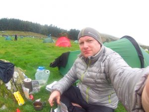
midway camp, waiting for the kettle to boil, detritus all around!
Heavy for this sort of event – the elites would be running with between 4 and 6 kg’s. Personally I prefer a bit of comfort these days so as long as its around 9kg starting weight its good enough for me. I camped next to a competitor who finished in the top ten – she was a tougher nut than I! With a real lightweight purist approach to her kit… may be one day eh?
A good running mate has decided that he is to take on the challenge of the Bob Graham Round in summer 2017. For those that do not know, this is a historic fell running challenge, first completed by hotelier – Bob Graham in 1932, where by he set out to travel 66 miles including 42 peaks (Wainwrights) within 24 hours. The challenge now has summer and winter completions, clockwise and anti-clockwise route choice and a whole lot of folklore surrounding it.
My mate, just fancies “having a go”. And why not! My running club, Clayton -le-Moors Harriers has a long record in fell running and ‘BG’ attempts. With several members having completed BG’s or supported BG’s there is no shortage of expertise in the route. With a small hardy group of 7 (and Rosie) we arranged to meet in Threlkeld at the “leg change over” point so we could pile in to one vehicle to drive down to Dunmail Raise to then run back to the other car. CleM run the BG anticlockwise. I don’t know why… why not?
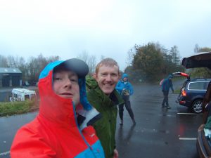
Threlkeld in the rain. Before we set off
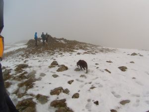
The forecast was mixed, but with all saying sub zero in the wind, wet and fog/mist for much of the day we all took the decision to set off in full waterproofs. For a fell runner – that never happens! By the top of Seat Sandal, the first of our 11 “peaks” on this leg the decision was justified, with snow on the ground still and moisture pretty much everywhere, progress was steady, with time taken to view alternative lines of ascent and descent between the peaks on route.
top of Fairfield
All of us are experienced runners and mountain walkers so staying fueled, hydrated and warm was easy as all of us kept tabs on each other. The youngest member of the group (aged 8 – Rosie) got extra attention, especially when the snacks were broken out!
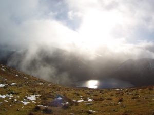
Our day – approximately 23km, with 1600m of ascent took us over Helvellyn and the Dodds, some of the Lake’s biggest mountains and a cracking days walk for anyone. We were rewarded by the fog and mist lifting briefly as we came off Fairfield toward Grisedale Tarn, before Dollywagon Pike. What a view!
looking across Grisedale Tarn to Seat Sandal and Fairfield, from the slopes of Dollywaggon Pike
We made good progress and got back to the car (and near by pub) in five hours, with the weather improving all the time as soon as we got off Clough Head. My lessons learned were very much personal -I can’t imagine the time when I will be fit enough to even dream about doing my own BG! Other then that all my gear worked and I was comfortable all the way round, we didn’t need the group shelter as we didn’t stop long enough to need it. It made a pleasant change to not be focussed on the nav for this one as three of the party have done and supported multiple BG’s – their ‘local knowledge’ was astounding. Given how poor visibility was for much of the route I think I saw two bearings being taken all day!