Another winter, another Open 5 series… Yay! I look forward to these in a big way, once Barley Badgers start night running on Pendle again I know its not long to wait before the Open 5’s kick off. Previous Open 5 posts and an explanation of the format are here. This season there are only three events, every other month which I am disappointed about, but with Dark Mountains coming up in January, perhaps that’s no bad thing!
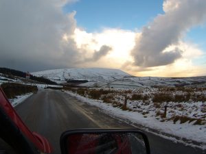
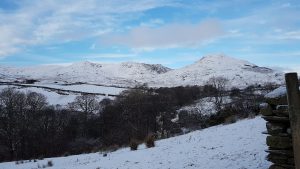
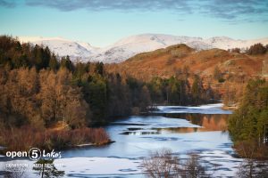
Coniston. An area I know well having biked, walked, run, camped, climbed and raced around before, bring it on. Feeling quite fit, with a sound bike under me I was fired up… the only curve ball might be the weather. the forecast for the preceding few days was for heavy snow, with yellow and amber warnings from the midlands up I loaded a van on Friday ready for an epic journey and was prepared to battle up the night before to ensure I could reach the start line….but on the Saturday (day before) the forecast changed and it looked like benign conditions, for the journey and settled snow and ice around Coniston with sunny skies promised too. Perfect conditions for an entertaining race.
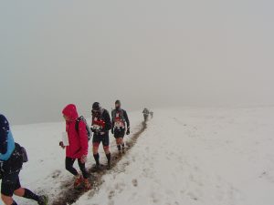
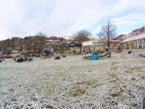
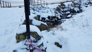
With low level patches of snow and ice and definitely snow on the ground the scene was a pretty one.
Last season I had biked first, then run. Time to go back to run first then bike. The theory being no matter how tired I am I can bike faster than I can run and if all else fails I would be able to walk and push the bike. Last seasons experiment hadn’t done anything to convince me biking first was a better bet.
The first job on collecting the map for me is to try and come up with a possible run and bike strategy, its a rough sketch of a plan as the control points values are not given to you until you cross the start line and the clock is ticking. This map revealed a few controls along the lake shore, meaning a good flat run, that appeals to me as it gets me warmed up and the blood pumping rather than straight over the line and uphill – which any where north of the Start line would be, so subject to points values, I would be heading south first. The bike was more complex with some fast roads in and out of Coniston and a big hill or two in either direction I decided it was an anti or clockwise choice, involving the quarries or not subject to how many points were available.
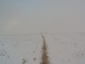
I started at 9.21 by my watch, meaning I had to be back for 14.21, I knelt down on some dryish looking tarmac to mark up the map…clock ticking. My plan was sound for the run, the bike bit was looking like skipping the quarries and heading east first. I would reflect more on that later. So I tore off at a good pace heading toward Coniston Hall and the water. With three controls bagged in the first 25 minutes I was feeling good and the conditions although intermittently slippy (wearing my usual roclite 280’s) it was definitely runnable. Sub zero and crisp – a beautiful morning! I try to bag points against time and scoring something every fifteen minutes is my usual aim, I was well on plan… but maybe I paused and took one too many pictures..? Still part of doing this is all about appreciating where I am. Well it is for me anyway!
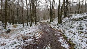
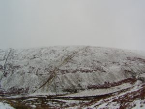
The real uphill began at Little Arrow, a path I know well and my aim was Walna Scar Road to pick up the furthest westerly controls before heading back to Transition, bagging a few more on the way. Its been a while since I last ran in snow and it definitely hit my pace, but by now I was just beaming, I love running being out in conditions like this.
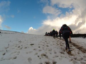
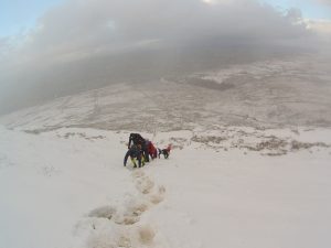
The Walna Scar Road was a mix of runnable compact snow and icy patches easily avoided. I knew it was time to start heading in once I had bagged 34 on Torver Bridge, but a part of me was thinking its cracking out here, should I just complete the run course and get all the points (250) and give myself only a short bike? But no, I bailed out of that thought process as there are 350 points available on the bike so I picked up the controls close to the main track on my way back in (32&30). I did take a tumble on the hill into town, some black ice caught me out, but in true fell running style I bounced back up, although as I type this my elbow is still bloody sore!
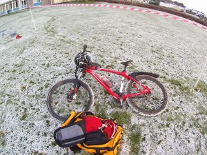
At transition I prepared to bike and whilst slurping on some soup and scoffing a scotch egg (the food of champions) I nailed my bike plan down to east first toward Hawkshead and then north toward Skelwith. I knew most of these tracks and roads so figured with an unknown quantity of ice on the roads I would manage that better on familiar territory. The plan started with control 16, worth a bold 30 points…… which wasn’t where it was marked on the map. I expected the way mark with control on it no more than a couple of hundred metres from the buildings, yet I reached my catching feature (a sharp bend in the track with no control. I stopped and checked the map again, measuring for accuracy… I knew where I was for sure, but no control. I noticed a marshal on the course – very rare to see one of those on these events…”so where is it then?” I asked, “a bit further up” was the reply, so I carried on and sure enough another few hundred metres up the track there was a marshal holding control 16 in his hand, “its in the wrong place then eh?” I offered, “yes, we are thinking of moving it” came the reply. “I would” -beep-“cheers!”. In the seven years I have been doing these events I think is the first time a control has been marked on the map wrong/placed wrong (depending upon how you look at it). No big issue, It cost me maybe three or four minutes or so maximum. Onward!
The next few controls were where I expected them to be, so things were going well. Really well to be honest and I started thinking this could be a really good day following on from a great run, a fun bike trip and then a possible good score (350+ ish I reckoned) to boot! I got to control 11 with my plan being to head up and over to 10 before hitting Hodge Close and then the fast track back to town. I had an hour to play with and felt confident of squeezing it all in time. I then looked at the on the ground conditions – boggy icy hell it looked like, up a steepening hill, a theory supported by the chap coming down, who suggested it was like that all the way up, I would be managing a slow trudge at best, so I decided to drop control 10 (worth 20pts) and pile down to Yewfield and go over Tarn Hows to pick up the main road, control 14&15 and then in to the finish, if I got there sharp I could possibly get the 20 pointer at Hodge Close there and back. Head down and peddle!
It was looking like a good plan right up to to the point I got to the parking place at Tarn Hows. The road down the hill on the other side was sheet ice and looked and felt treacherous. I stayed on my bike, but images of a fast descent froze in the winter sun and I trickled down the tarmac hill painfully slowly. I got to 14 knowing I was going to have to drop the 20 pointer at Hodge Close, but I had time (about 15 minutes) to get back in the five hours,so I set off at a pace to be proud of 4 hours 45 minutes into the event and was buzzing right up to the puncture! My first ever competitive puncture! ARRGGGHH! I reckoned I had just under 2km to go and a control to find. I think I got the hole dodging some kids on the track out for a walk, I am sure I went over a bramble branch and that’s what got me (as I write this I have yet to repair it…). My thought process was this, put a new inner tube in and peddle back, having got really cold (hands especially) and be late in or just run the bike back in, be late – but stay warm. Well, warm won out so I started trotting… Thank you to all those who inquired if I was okay..”yep, just a puncture” was the often repeated reply, I got 15 (worth 30 points) with three minutes to spare and I eventually crossed the finish line seven minutes over time. Bugger! The points loss, coupled with the forty points I Left on the course left me with a disappointing 314 after penalties, well down the field.
Whilst chatting to other competitors (Steve and Andy) it turned out I wasn’t the only one who had considered having a long run and shorter bike – they had executed that plan and done really well on it scoring 370 each! Next time I might give that plan some more serious thought, I would say I am a better runner than MTB’er. Having scanned the results there were some big scores which seemed run heavy/bike light. Perhaps I missed a trick there.
Irrespective of a disappointing result I had a fantastic day, the course planners did a great job offering some testing route choices and well positioned controls. Roll on Edale in February!